National Park Service Climate Change Decision Support
Develop data-enabled tools that empower park managers to decide how best to track and manage an area after it has burned
The Problem
The National Park Service (NPS) oversees vast protected lands in all fifty states, totaling 85 million acres (an area 12 times the size of Massachusetts). These lands serve as critical refuges in a changing climate, support threatened species, and act as vital carbon sinks, sequestering millions of metric tons of carbon dioxide annually.
We know that a grand climate change-driven challenge for the NPS and for the west itself is fire. Megafire upon megafire have ravaged these iconic locations leading to an urgent need to understand and address all challenges related to fire. And, while significant resources have been allocated to fire prevention and preparedness, there is very little ongoing effort to address recovery and how best to manage a landscape in the time sensitive periods after it has burned.
The Opportunity
We have a unique and exciting opportunity to work hand in hand with the NPS to develop first of its kind decision support tools on fire, and over time for a wide range of climate challenges. Through the generous and timely award granted by NPS, we are able to focus resources on this work in a concentrated way, allocating designated data science and academic staff to the rapid advancements of tools to meet NPS needs.
Our Vision
Schmidt DSE intends to develop data-enabled tools that empower park managers to decide how best to track and manage an area after it has burned, something that unfortunately will happen more and more in our parks each year. While many tools have been developed to help detect and stop wildlife, the niche of using data science tools to helpfully restore lands after a fire remains an underserved area.
Where we are
We narrowed in on our initial fire recovery project area through a careful assessment of feasibility, user needs, impact, partnership opportunities, and scalability.
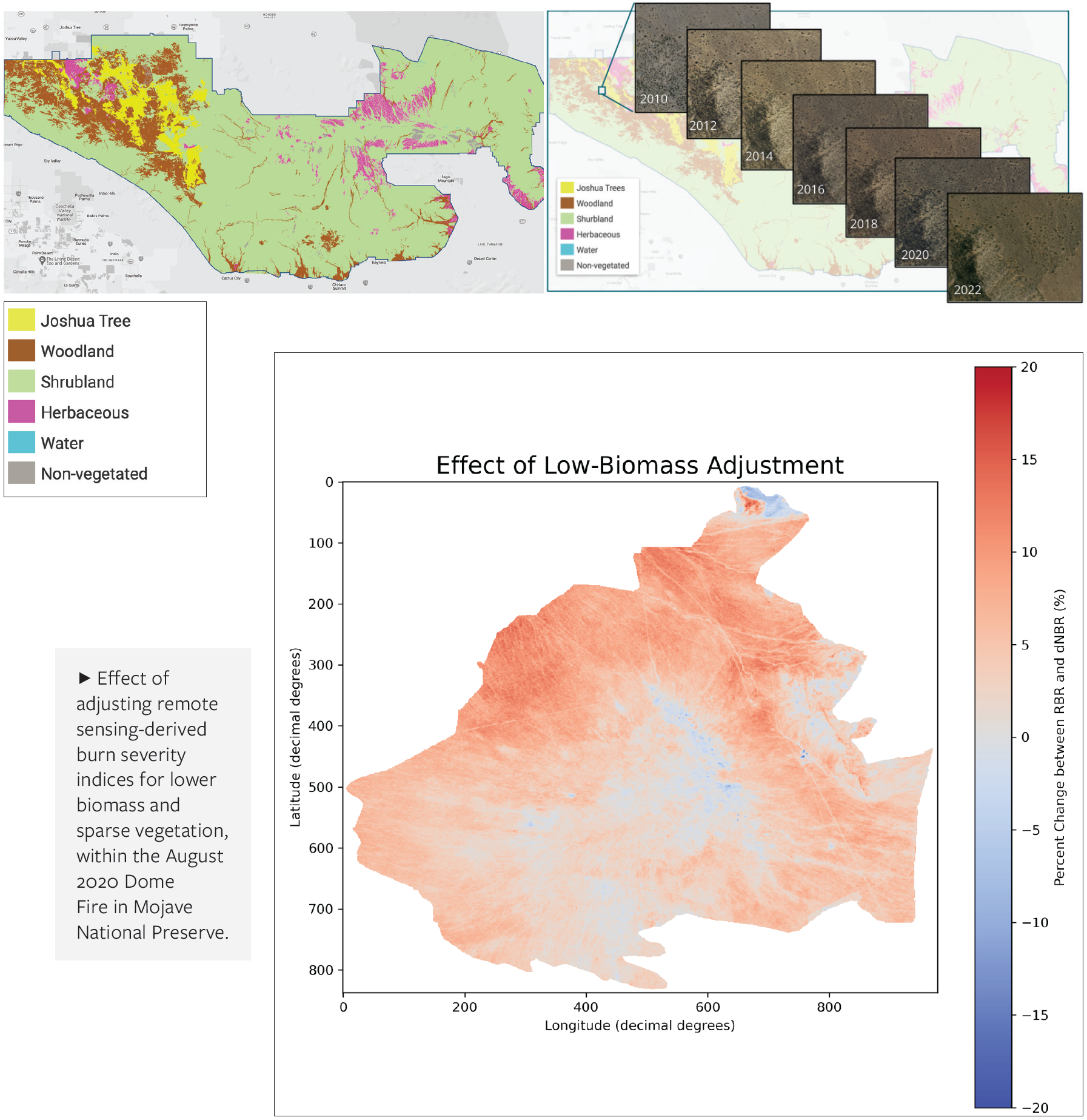
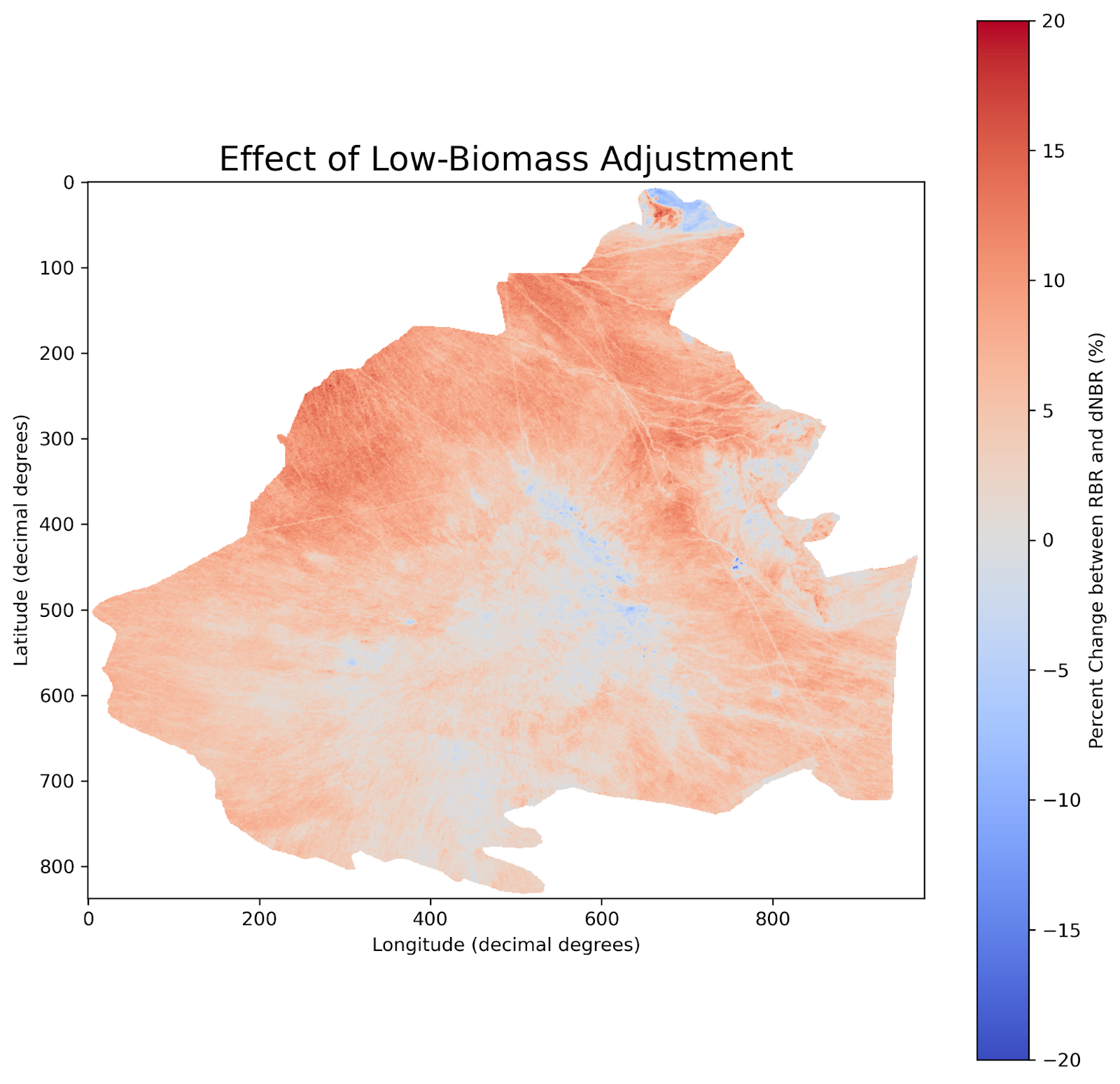
Exploring Understudied Areas: While our primary deliverables are still under consideration, we are enthusiastic about how our AI-enabled remote sensing capabilities may be used to improve near real-time high resolution mapping in places like Joshua Tree National Park, a practice that has previously required years of laborious work.
Building Partnership: Partnership was a crucial factor, with NPS partners showing enthusiasm to actively engage in the co-design and iterative refinement of the tool, including hosting our team in an on site visit to the park. Their willingness to provide feedback greatly enhances our collaborative efforts.
Filling an Urgent Need: Our NPS partners enthusiastically requested an initial tool assessing fire severity in the immediate aftermath of fire events, which they can use to quickly build out their emergency response plans. We have devised a quickly executable, satellite imagery driven tool that is tuned to the ecological subtleties of the desert ecosystem.
Where we are going
Fire Recovery Toolbox: Supported by our forthcoming NPS post doctoral researcher, we see the eventual product for fire recovery as a toolbox that centralizes existing resources and our bespoke tools in a single location (another partner request). Ambitious tooling directions include linking our burn severity mapper to species specific mortality predictions, and eventually vegetative succession modeling, which would allow users to project the future of a burned area under a range of recovery/intervention scenarios and considering future climate expectations.
Scaling our Work: Our aim in developing an initial pilot project is to demonstrate the utility of how data-enabled decision support tools can help NPS managers to make better decisions related to the climate impacts that are, and will continue, impacting these landscapes. Scalability is an essential element of our approach, as we aim to create a tool that can be refined and adapted for use in diverse geographies, landscapes, and for various species. Our prototypes in one park can be adapted and scaled to eventually benefit additional parks and protected areas both throughout the US and globally.